Join us for a free one-day workshop for educators at the Japanese American National Museum, hosted by the USC U.S.-China Institute and the National Consortium for Teaching about Asia. This workshop will include a guided tour of the beloved exhibition Common Ground: The Heart of Community, slated to close permanently in January 2025. Following the tour, learn strategies for engaging students in the primary source artifacts, images, and documents found in JANM’s vast collection and discover classroom-ready resources to support teaching and learning about the Japanese American experience.
Ma Ying-jeou, Remarks on Taiping Island, January 28, 2016
Ma Ying-jeou, president of the Republic of China (Taiwan), visited Taiping Island in the South China Sea. His predecessor, Chen Shuibian, also visited the island in 2008.
January 28, 2016
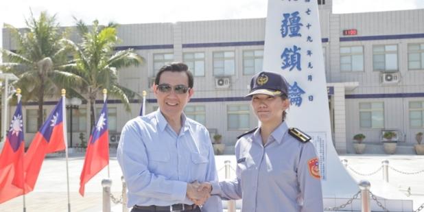
I am very happy to be here today on Taiping Island ahead of the Lunar New Year with all of you stationed in the Nansha Islands, part of the southern territories of the Republic of China. In addition to affirming your hard work and sacrifices, I want to wish everyone a happy new year. Before every Lunar New Year I pay special visits to our men and women in the military, police, fire departments, coast guard, medical services, and environmental protection. This year I am starting with our coast guard personnel stationed furthest from Taiwan proper, here 1,600 kilometers away on Taiping Island, to show the great importance we attach to you and your mission.
I. South China Sea Peace Initiative Roadmap
In response to the decades of dispute regarding sovereignty over the South China Sea Islands and maritime rights, we must state clearly that these islands were first discovered, named, and used by the Chinese in the Western Han dynasty (in the first century BCE). They were incorporated into the maritime defense system no later than 1721, in the Kangxi period of the Qing dynasty, with patrols and other management measures. After the ROC was founded in 1912, the government published maps of the South China Sea Islands in 1935 and 1947, reaffirming to the international community ROC sovereignty over the islands and their surrounding waters.
Whether from the perspective of history, geography, or international law, the Nansha (Spratly) Islands, Shisha (Paracel) Islands, Chungsha (Macclesfield Bank) Islands, and Tungsha (Pratas) Islands, as well as their surrounding waters, are an inherent part of ROC territory and waters, and the ROC enjoys all rights over these islands and their surrounding waters in accordance with international law. This is indisputable. To resolve disputes in the South China Sea, the ROC government will work to safeguard sovereignty, shelve disputes, pursue peace and reciprocity, and promote joint development.
Based on this approach, on May 26, 2015, I put forth the South China Sea Peace Initiative, calling on all parties concerned to reduce tensions, increase dialogue, abide by international law, uphold the freedom of navigation and overflight, maintain peace and stability in the South China Sea, and settle disputes peacefully. The initiative and its principles for handling disputes have received widespread international support, including an expression of appreciation by the US State Department. We saw the first fruits of the initiative on November 5 last year, when the ROC and the Philippines signed the Agreement Concerning the Facilitation of Cooperation on Law Enforcement in Fisheries Matters, which will greatly reduce fisheries disputes in the overlapping waters of Taiwan and the Philippines.
Now I would like to announce the South China Sea Peace Initiative Roadmap, which is based on a framework of three yeses and three noes.
1. “Yes” to cooperation, “no” to confrontation: A cooperation and development mechanism that contributes to peace and prosperity in the South China Sea should first be established, and sovereignty disputes should be set aside for future resolution through peaceful means.
2. “Yes” to sharing, “no” to monopolizing: A cooperation and development mechanism should ensure equal participation and resource sharing among all parties concerned in the region in order to avoid undermining the rights and interests of any party.
3. “Yes” to pragmatism, “no” to intransigence: The initial focus should be on aspects which are beneficial to all parties concerned and on which consensus can be easily achieved; various cooperation items should be pragmatically and gradually promoted so as to avoid missing out on cooperation opportunities as a result of any party insisting on its position.
Next I will lay out the concrete content of the roadmap, including a viable path, two essential elaborations, and three phases of progress.
The viable path consists of shelving disputes, integrated planning, and zonal development.
The two essential elaborations are:
First, all parties concerned in the region should be included in the consultation mechanism for this initiative so that they can engage in cooperation and negotiations on integrated planning for the South China Sea.
Second, the cooperation and consultation mechanism proposed in this initiative should be a provisional arrangement of a practical nature, and should not undermine the position of any party concerned or jeopardize or hamper the reaching of a final agreement on the South China Sea.
Lastly, we’ve mapped out three phases of progress, namely short-term, mid-term, and long-term plans.
In the short term, we need to jointly shelve disputes. All parties concerned in the region should launch multilateral dialogue and consultations as soon as possible with a view to reaching a consensus that sovereignty disputes be shelved. In accordance with the spirit and principles of the UN Charter, the UN Convention on the Law of the Sea, and other relevant international law, the parties should pledge to replace military confrontation with peaceful consultations, refrain from taking any actions that might affect stability and peace in the South China Sea, and ensure the freedom and safety of navigation and overflight through the South China Sea. After building sufficient mutual trust, the parties should negotiate codes of conduct regarding unexpected sea or air encounters in the South China Sea area, as well as the establishment of hotlines and other security mechanisms.
In the midterm, we will push for integrated planning. All parties concerned in the region, in accordance with the spirit and principles of relevant international law, should jointly establish cooperation mechanisms so as to engage in coordination and cooperation on important issues such as living resources conservation and management, non-living resources exploration and exploitation, marine environmental protection and scientific research, maritime crime prevention, humanitarian assistance and disaster relief.
In the long term, as part of overall integrated planning, we look forward to the establishment of a mechanism for zonal development. Through bilateral or multilateral cooperation, parties concerned could designate specific maritime areas for provisional cooperation and development, with a view to establishing a joint management and monitoring mechanism so as to engage in cooperation and development on an area-by-area, stage-by-stage basis. Thus, fair and reciprocal win-win results can be achieved.
II. Peaceful use of Taiping Island
In accordance with the policy of safeguarding sovereignty, shelving disputes, pursuing peace and reciprocity, and promoting joint development, the ROC has advocated the peaceful use of Taiping Island. In fact, in 2000, the Coast Guard Administration (CGA) took over defense of Taiping Island from the ROC Marine Corps. This concrete action served to demonstrate our clear opposition to the militarization of the South China Sea.
To create opportunities for cooperation between parties concerned in the region, the ROC government, taking Taiping Island as the starting point for implementation of the South China Sea Peace Initiative, is working to transform it into an island for peace and rescue operations, as well as an ecologically friendly and low-carbon island.
With regard to making it an ecologically friendly island, the Ministry of the Interior and the Council of Agriculture have jointly conducted a water quality and agricultural environment survey project, so as to gain a better understanding of the natural resources on Taiping Island and help maintain its ecological balance. In addition, the CGA is conducting a survey of natural vegetation, classifying the different types of trees on the island in order to implement preservation work. Meanwhile, in 1978, a station was set up on Taiping Island to monitor the winter monsoon as part of a large-scale global project conducted by the World Meteorological Organization (WMO). We will continue to upgrade the scientific research equipment on Taiping Island to monitor earthquakes and marine and weather patterns, survey the ecology on the island, and observe the quality of its environment. We aim to establish the Nansha International Research Station and initiate transnational scientific research projects, so as to strengthen the peaceful use of the island and expand international cooperation on ecological research.
As for making Taiping Island a low-carbon island, the Ministry of Economic Affairs and the CGA are jointly working on a project concerning the provision and management of water and electricity on the island. The purpose of this project is to expand solar power systems on the island and raise their ratio of total electricity supply on the island to 40 percent. Taiping Island will thereby serve as a model for saving energy and reducing carbon emissions.
And as for making Taiping Island an island for peace and rescue operations, on December 12, 2015, the Minister of the Interior, the Minister of the CGA, as well as other relevant government officials, presided over a ceremony marking the completion of the renovation of the island’s wharf and the construction of a lighthouse. The wharf has a length of 318 meters and width of 20 meters, and can accommodate 3,000-ton ships. In conjunction with the lighthouse, it can effectively shorten supply times and ensure safety of navigation in the waters surrounding Taiping Island. This benefits humanitarian assistance and rescue operations, fishing operations, as well as maritime navigation in the area. Moreover, renovation of the island’s airstrip was completed on November 25, 2015, allowing C-130 Hercules transport planes to take off from and land on the island. Meanwhile, the data obtained from marine and meteorological observation stations can be used to monitor natural disasters and contribute to relevant warning mechanisms. We will also strengthen the facilities of Nansha Hospital and medical equipment on the island, and coordinate with international medical organizations to establish an emergency rescue center that can serve as a relay station for relevant operations. This will enhance our humanitarian assistance capabilities and help implement the spirit of the South China Sea Peace Initiative, thereby making Taiping Island an island for peace and rescue operations.
Through these concrete actions, we aim to demonstrate to the international community that the Republic of China is committed to fulfilling its international obligations and actively serving as a peacemaker and provider of humanitarian aid, so as to truly transform the South China Sea into a sea of peace and cooperation.
At the same time, we very much hope that parties concerned can set up coordination and cooperation mechanisms in the South China Sea concerning nontraditional security issues such as environmental protection, marine research, the fight against maritime crime, humanitarian assistance, and disaster rescue operations.
On January 19 this year, I attended the International Symposium on Oceanic and Atmospheric Research in the South China Sea. At this event, many domestic and foreign scholars and experts held wide-ranging discussions on scientific research in the South China Sea and on Taiping Island. In fact, the attendees showed great interest in the current development of Taiping Island and the vision for its future. We do not exclude the possibility of holding international seminars on Taiping Island in the future. Even though the conference room on Taiping Island can only accommodate about 30 people, through videoconferencing we can link to cities in Taiwan and around the world, thus sharing the Republic of China’s efforts on Taiping Island to promote the peaceful use of the South China Sea with the rest of the world.
III. Freshwater, agricultural products, and status in international law Taiping Island, an inherent part of the territory of the Republic of China, is, at 0.51 square kilometers, the largest island in the Nanshas, and the only natural island with a supply of freshwater. In December 1946, following World War II, our government dispatched the ROCS Taiping to recover Taiping Island. While our forces were withdrawn from the island starting in June 1950 due to supply issues, they have been on the island now for nearly 60 unbroken years starting in June 1956.
The Philippines sought arbitration with the Permanent Court of Arbitration in 2013 concerning competing claims with mainland China vis-à-vis the South China Sea. This arbitration is of particular importance to our country, yet we have not been invited to participate, nor has our opinion on the matter been sought. The Philippines holds that Taiping Island has no freshwater, and no arable soil, claiming that food and water must all be imported and human habitation is impossible. This, the Philippines says, means that it is not an island, but a rock, to which no claim can be made on territorial waters beyond 12 nautical miles. However, such statements find no basis in either science or fact; they are totally wrong. The economic, environmental, and cultural realms all provide evidence sufficient to show that the island has—and has had for over 100 years—ample resources to be self-sufficient.
Geological study of the island shows that Taiping Island was formed perhaps 3 million years ago. Roughly 20,000 years ago, it rose upward to 100 meters above sea level. Perhaps this sheds light on why Taiping Island became the only island in the Nanshas to have its own sources of potable water.
Annual rainfall on Taiping Island is roughly 3,000 mm. Rainwater is either trapped by the soil or seeps down into the coral below. The coral layer further down, having been there for a million years, has been lithified and become impervious to water, meaning that the island has a rich supply of groundwater. Water from the best well, the No. 5 well, has been tested by experts and found to be close to that marketed internationally under the brand name Evian in terms of conductivity and total dissolved solids. It can be drunk directly, and tastes as good as mineral water sold in stores.
Historical documentary evidence attests to the presence of freshwater on the island. The earliest appearance of such documents is in 1879, with the Royal Navy’s The China Sea Directory, in which it attests to the use of Taiping Island by Chinese fishermen and the presence of wells, of which it states, “The water found in the well on that island was better than elsewhere.” In 1939, a survey report on Taiping Island by a technician working at Taichu Prefecture (today’s Taichung City, Changhua County, and Nantou County) states that “the island has abundant potable water, sufficient for both fishing vessels and for use on the island itself.” In 1946, a report written during a survey of the Nansha Islands by an ROC naval flotilla states that “there are several wells on the island, the water drawn from which is excellent.” In 1994, the Council of Agriculture, in “Nanhai Shengtai Huanjing Diaocha Yanjiu Baogao,” a report on the ecology of the South China Sea, states that the freshwater at two places on Taiping Island is of better quality than that found in most rivers or lakes. The Coast Guard Administration, meanwhile, last December released “Living Conditions on Taiping Island,” which states that of the four wells on the island, the water of one is used to raise tilapia, while the other three can provide 65 tons of freshwater daily, and that on the average freshwater accounts for 92 percent of water drawn from these wells. Water drawn from Well No. 5, meanwhile, is 99 percent freshwater of good quality. History thus attests to the plenitude and quality of freshwater on Taiping Island, sufficient to support human life.
The soil of Taiping Island has also been examined by experts. Entisols of some 20 cm in thickness have been formed over 1,000 years of wind erosion. The aggregate is lush with organic material. Guano has mixed with this, making for fertile soil amenable to the growth of both indigenous plants and agricultural products.
Due to its favorable soil and water conditions, Taiping Island has an abundance of natural vegetation. Its primeval coastal forest area is fairly dense, effectively conserving water resources, preventing forest transpiration, and replenishing soil humus. Purple-stalk sword ferns flourish among the undergrowth. As these ferns grow only in a stable forest environment, they further show that Taiping Island has an excellent natural ecological environment.
Taiping Island has as many as 106 land-based indigenous plant species. These include several hundred large tropical trees, such as the lantern tree (Hernandia nymphaeifolia), Indian almond (Terminalia catappa), and fish poison tree (Barringtonia asiatica), which are between 20 and 30 meters tall, have girths greater than 100 centimeters, and are more than 100 years old. Other wild crops, such as coconut, papaya, and plantain, grow in abundance all year round. There are approximately 500 coconut trees, producing about 1,500 wonderfully flavored coconuts each year. Some 200 to 300 kilograms of high-quality papayas and plantains are harvested annually. Personnel stationed on the island have long utilized the natural environment and cultivated over a dozen tropical vegetables and fruits on the island farm, including bitter melon, loofah squash, sweet potato, bottle gourd, pumpkin, okra, corn, cabbage, sweet potato leaves, and chili pepper. In addition, chickens (180 in number), goats (12), and dogs (6) live on the island. The dogs act as guards during the night while the goats, chickens, and eggs are a source of food that meets the nutritional needs of people on the island.
The Nansha Hospital on Taiping Island has two physicians and a dentist, three nurses, 10 hospital beds, and videoconferencing equipment connecting to hospitals in Kaohsiung. There is also a post office and a Guanyin Temple on the island. Aside from groundwater wells that provide water for daily use, water can also be obtained through seawater desalination, reverse osmosis, and recycling. Electricity is provided through diesel generators and a solar power system that generates up to 170,000 KWH per year. Other facilities supporting daily life such as mobile telecommunications; postal services; satellite television; an airstrip, wharf, and lighthouse; navigation facilities; household registration; and administration services are also complete. All this evidence fully demonstrates that Taiping Island is able to sustain human habitation and an economic life of its own. Taiping Island is categorically not a rock, but an island, and meets the criteria for an island as specified in Article 121 of UNCLOS. Therefore, in addition to territorial waters, we are also entitled to claim an exclusive economic zone and continental shelf. Moreover, that the island has been garrisoned and managed by the ROC over a long period is further proof of the ROC exercising its sovereignty over Taiping Island and the surrounding areas. That some in the international community doubt this may be due to the fact that they have never set foot on Taiping Island. We welcome these people to Taiping Island to see the truth for themselves.
IV. Conclusion
Lastly, I would like to wish everyone the best of health and happiness. May there be peace in the South China Sea, and may our national territory remain forever assured. Thank you!
Click the video below for the Taiwanese official news agency's coverage of the visit.
外交部:太平島為島嶼 絕非岩礁帶您認識這個南沙群島中面積最大的自然生成島嶼http://www.cna.com.tw/news/firstnews/201511020374-1.aspx
Posted by 中央社新聞粉絲團 on Monday, November 2, 2015
Featured Articles
October 20, 2024
October 20, 2024
Please join us for the Grad Mixer! Hosted by USC Annenberg Office of International Affairs, Enjoy food, drink and conversation with fellow students across USC Annenberg. Graduate students from any field are welcome to join, so it is a great opportunity to meet fellow students with IR/foreign policy-related research topics and interests.
RSVP link: https://forms.gle/1zer188RE9dCS6Ho6
Events
Wednesday, November 20, 2024 - 3:00pm
Hosted by USC Annenberg Office of International Affairs, enjoy food, drink and conversation with fellow international students.
Thursday, November 7, 2024 - 4:00pm
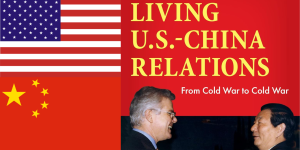
Join us for an in-person conversation on Thursday, November 7th at 4pm with author David M. Lampton as he discusses his new book, Living U.S.-China Relations: From Cold War to Cold War. The book examines the history of U.S.-China relations across eight U.S. presidential administrations.